MARATONA DLES DOLOMITES
I took a little trip and rode my bicycle in the Maratona dles Dolomites on Sunday morning.
In a nutshell, this ride is well supported, well routed(on closed roads) through some of the most beautiful land in the world, and well attended. This year, the ride was limited to 8500 riders who can choose one of three routes to ride.
* The shortest route is 55km with 1780m climbing (34 miles / 5872 ft.)
* The middle route is 110km with 3090m climbing (66 miles / 10,137 ft. )
* The long route is 138km with 4190m climbing. (86 miles / 13,746 ft.)
In other words: Hard, harder, and freakin' greuling!!
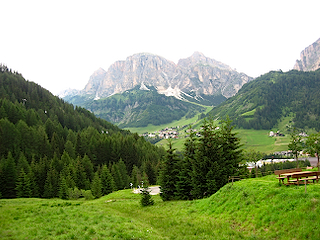
The ride takes place in the heart of Dolomites in the area around Alta Badia and Corvara, Italy. This region of Italy, the SüdTirol, is in northern Italy about 1 hour drive south of Innsbruck. What is especially interesting to me about this area is the amount of German spoken instead of Italian. It feels much more like being in south Austria (SüdTirol means South Tirol. Tirol is a province of Austria that I rather enjoy visiting in winter!)
Originally, I had planned to sleep in the car where a colleague had suggested, but at the lat minute chickened out and got a hotel room. Since the ride takes place in "the mountains" and there are 8000+ people riding, plus support, pluslocals, plus the other unsuspecting toursts, plus the not-to-happy motorcyclists who came to ride, but found many of the roads closed.
I stayed at a nice little hotel, the Hotel Langgenhof in Bruneck (Brunico) about 30 minutes drive from the start. They advertise "Our house maintains the old traditions of Tyrolean hospitality: ….natural and casual or classical and elegant but always friendly"...I totally agree. My stay, although very short, was very pleasant. I had a nice walk around the town of Bruneck, followed by a dinner of wine and Gulash, a local tradition I was told. Not exactly the best pre-race meal, but it was tasty.
So, Sunday morning came early with the alarm set to 4:45. Get up, get dressed, drive a half-hour down to Pedraces, get the bike down, climb on, and ride the last two miles to the start area....Then Wait
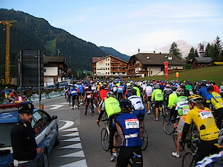
I was seeded in the last group. My section was the last to start. So, I was about 8400th across the start line.
No problem, that just leaves me more people to pass! BIG problem later when I realize that my slow climbing and extra stops were going to make me miss the time cutoff for the middle distance. Oh well. Maybe next year.

Before I go on.....
I saw this car while driving around the area the night before the ride.
How do you say 'YEEE HAAAAA' in Italian??
(Forza Azzuri??)
In the end it was a fun ride. Not quite so fun during the long climbs, but the overall feeling of accomplishment was fantastic.
I received an email the next day with a link to the standings(all bikes had numbers with a transponder):
Name: Robert Sayman
Startnummer: 9000
Land/Ort: D-Meckenbeuren
Kategorie: 55km Uomini/Herren 37-42 anni
Startzeit: 6:50.34,9 Zielzeit: 10:54.08,3
Fahrzeit: 4:03.33,4
Durchschnitt: 13,549 km/h
Startnummer: 9000
Land/Ort: D-Meckenbeuren
Kategorie: 55km Uomini/Herren 37-42 anni
Startzeit: 6:50.34,9 Zielzeit: 10:54.08,3
Fahrzeit: 4:03.33,4
Durchschnitt: 13,549 km/h
Rang Gesamt: 847.
Rang Kategorie: 178.
Durchgangszeiten auf der Strecke
Stelle Tageszeit Fahrzeit Rang Gesamt
---------------------------------------------------------------
Gardena 10:37.34,0 3:46.59,1 183. 860.
Rang Kategorie: 178.
Durchgangszeiten auf der Strecke
Stelle Tageszeit Fahrzeit Rang Gesamt
---------------------------------------------------------------
Gardena 10:37.34,0 3:46.59,1 183. 860.
What this says is that I averaged 13,549 km/h over 4 hours and 3 minutes for the entire ride. My rank, for the 55km ride, was 847th out of 1286 people, and 178th out of 242 men 37-42 years old. Definitely room for improvement...
I even have a diploma, online, here: http://www.datasport.com/diplom/opendiplom.cfm?racenr=9422&stnr=9000

There are a two pictures of me that I have found in the available commercial photographs, but cannot seem to buy them. So, here they are with the watermark still attached.

If someone can help me buy them from fotostudio5.net, please let me know.
My next planned ride is at the"Lightweight Uphill"
Stay Tuned....